
The Department of Housing, Local Government and Heritage (DHLGH) published a Notice of intention to Designate Porcupine Shelf and Southern Canyons as Special Areas of Conservation (SAC) in November 2022. These large areas (the Porcupine Shelf SAC is c.14,718 km² and the Southern Canyons SAC 14,448 km²) are being proposed based on the suggested presence of ‘Reefs’, which is an Annex I habitat of the EU Habitats Directive.
Whilst fishing is not immediately excluded from the proposed SACs or listed as an ‘Activity Requiring Consent’ (ARC) there is concern that once designated as SACs this will ultimately lead to closure of the areas to fishing or restriction of particular fishing activities. There is precedent for this in the case of other offshore SACs (Belgica Mound Province, Hovland Mound Province, Southwest Porcupine Bank and North-West Porcupine Bank), which were designated in 2016 and in 2019 were closed, under Regulation (EU) 2019/1241, to ‘bottom trawls or similar towed nets, bottom set gillnets, entangling nets or trammel nets and bottom set longlines’. Further restrictions on pelagic fishing vessels were also incorporated in the regulation including having to give four hours advance notification to the Irish Fisheries Monitoring Centre (FMC) of their intention to enter the areas. These concerns have recently been confirmed with the release of the ‘EU Action Plan: Protecting and restoring marine ecosystems for sustainable and resilient fisheries’, which includes the stated aim of prohibiting mobile bottom fishing in MPAs and SACs by the end of March 2024. While the Action Plan has no legal basis and is being strongly contested by member states it is indicative of the wider drive to phase out bottom trawling.
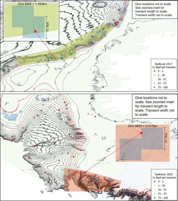
The KFO spent considerable time reviewing the underlying data for the proposed SACs and preparing a scientific objection to the proposals in their current form. As detailed in the objection (available through the link below) the evidence supporting the delineation of the SACs ranges from weak to non-existent. It largely consists of observations made on the 2017 and 2019 Sensitive Ecosystem Assessment and ROV Exploration of Reef (SeaRover) surveys undertaken by the Marine Institute. Whilst no details of the results of these surveys or the data underlying the proposed designations was provided with the Notice of Intention to Designate, with some searching it is possible to access the data through various open access repositories and reports. It transpires that only a tiny proportion of the proposed areas were actually surveyed at all (see figure) and that in the areas surveyed only a tiny proportion actually had any evidence of ‘Reefs’ habitat. In order to illustrate this point the KFO conducted its own basic analysis of the data. We estimated the % observed reef habitat within the Porcupine Shelf and Southern Canyons SACs, based on the evidence presented, to be 0.0013% and 0.000017% of the total area delineated areas, respectively. Further, none of the areas surveyed were shallower than 500m depth in the Porcupine Shelf area or 900m in the Southern Canyons area, so the inclusion of these areas in the proposed SAC polygons has no basis.
If the SACs are being proposed based on scientific evidence then they should align with that evidence and any extrapolation of this must be justified, which in this case it is not. Such extrapolation of evidence has also been seen in the identification of areas where Vulnerable Marine Ecosystems (VMEs) are known or are likely to occur according to ICES. Everyone will be familiar with the large number of closed areas that the EU implemented in September 2022 on the basis of the ICES VME advice. Given the high-resolution catch, VMS and survey data available to scientists this kind of broadscale generalised approach should not be taken and should not be used as the basis of policy or management decisions.
KFO Response to the Proposed Porcupine Bank and Southern Canyons SAC Designations